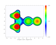
Thanks a lot. Yes it is.
I double checked it, it should be surface distance projection map. There is an example in Section 4.300.8 of manual.
Thanks for your reply. Actually the attached figure is mine but i do not know how i got it. I am trying to get the same map using the examples in section 4.4 but I could not get the same one that in the attached file. Do you have an idea what options i have to use to get the same result (Attached file) :-)
I don't exactly understand your question.
If you just want to save the plotted map to .png file, in the post-process menu of main function 4, select "0 Save the graph to a graphical file in current folder". By default, the graphical format is png.
If you don't know how to plot this kind of map, please check rich examples in Section 4.4 of Multiwfn manual.
